Survey and Monitoring -
Aerial Photography
Aerial photography, as it name suggests, is photographs taken from the air, normally from an aeroplane. It has been around for many years with the first images being taken from hot-air balloons or kites. The first large scale aerial photography datasets were created during the Second World War, many of them were Luftwaffe reconnaissance photographs.
There are two types of aerial photography, vertical and oblique. Vertical aerial photographs are taken looking straight down to the ground, at a right angle, to produce an image that would appear as a map does. An oblique aerial photography is taken at an angle, other than a right angle, to the ground. Both types of photography allow some interpretation of the picture, especially if the photography is repeated and changes can be identified.
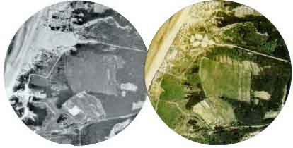
Victoria Road, Freshfield in 1975 (left) and 1989 (right) showing clear
differences in land use and dune condition.
Vertical photography is often prefered as it can be imported into a Geographical Information System (GIS) and used as a map base. Several datasets can be overlaid and changes can easily be seen. These changes can be digitised and quantified.
The quality and range of aerial photographs have developed over the years. Original photographs were in black and white and could only provide an approximate scale. Recent photographs are in full colour and can be accurately positioned and scaled. Along with this increased accuracy in position and scaling different types of film became available. False Colour Infra Red film allows vegetation to be better distinguised.
The Sefton Coast has a good coverage of aerial photography dating back to the late 1940's, though not every set is avaiable in digital format.
Aerial photography on the Sefton Coast has been used to assess coastal change, map habitats, for presentations and interpretation, to aid fieldwork, predictive modelling and derive topographic data.

